


Nautical map (The Netherlands)
Description of Nautical map (The Netherlands)
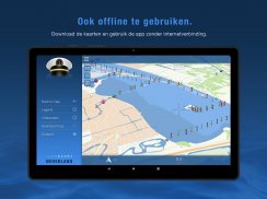
Nautical map (The Netherlands) is an online waterway chart and almanac designed to facilitate navigation and planning for water travel within The Netherlands. This app provides essential information for boaters, making it a valuable tool for both recreational and professional users. Individuals interested in exploring the waterways can easily download Nautical map on the Android platform to access its array of features.
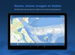
The app offers a detailed overview of over 8,000 buoys, barrels, and other floating waterway markings. This extensive database helps users identify navigational aids, ensuring safer passage through various water routes. Additionally, Nautical map includes information on more than 4,500 docks and wharfs, which can be crucial for those seeking docking locations and services along their journey.
Bridges are another significant aspect of the app. Nautical map provides data on over 2,500 bridges, including crucial details such as height, width, and operating times. This feature assists boaters in planning their routes more effectively, avoiding potential obstacles that may hinder their progress. Moreover, users can find information on more than 300 locks, complete with operating times, which is essential for navigating the intricate canal systems found throughout the region.
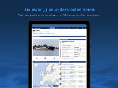
Real-time tracking is an integral part of Nautical map's functionality. The app displays the current speed and course of the user's vessel, providing valuable feedback for navigation. This feature allows boaters to make informed decisions during their travels, ensuring they stay on course and adhere to any speed regulations that may apply.
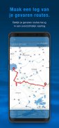
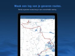
Graphical representation of the traveled route is another key feature that enhances the user experience. The app visually displays the path taken, allowing users to review their journey and make adjustments for future trips. This capability is particularly useful for those who navigate complex waterways or are unfamiliar with specific routes.
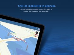
Nautical map (The Netherlands) is designed to cater to a wide range of users, from seasoned sailors to those new to boating. The app's user-friendly interface makes it accessible for individuals with varying levels of experience. Clear visuals and straightforward navigation tools help users quickly find the information they need.
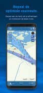
Planning a cruise is made more manageable with the resources provided by Nautical map. Users can access detailed information about various waterways, including conditions and potential hazards. This allows for better preparation and a more enjoyable experience on the water. The app's extensive data coverage ensures that users have access to the most relevant and up-to-date information.
In addition to its navigational features, Nautical map serves as an educational resource. Users can learn more about the waterways they traverse, including historical and environmental information. This aspect enhances the overall experience, encouraging a deeper appreciation for the natural beauty and cultural significance of The Netherlands' waterways.
The app also facilitates communication among boaters. Users can share experiences, tips, and information about specific locations, which fosters a sense of community among those who enjoy water travel. This collaborative aspect adds another layer of value to Nautical map, as it helps users connect with others who share their interests.
Safety is a priority for anyone navigating waterways, and Nautical map provides resources to help ensure a secure experience. The app includes information about local regulations and safety recommendations, empowering users to make informed choices while on the water. This focus on safety can help prevent accidents and promote responsible boating practices.
For those looking to enhance their navigation skills, Nautical map offers various tools to support learning. Users can experiment with route planning and familiarize themselves with the waterways, increasing their confidence as they gain experience. The app's informative features contribute to a better understanding of water navigation and the challenges it may present.
Incorporating Nautical map into a boating routine can lead to a more efficient and enjoyable experience. The app's comprehensive data, real-time tracking, and user-friendly design come together to create a robust tool for anyone interested in exploring The Netherlands' waterways. As users familiarize themselves with the app's features, they can expect to see improvements in their navigation capabilities and overall boating experience.
Nautical map (The Netherlands) stands out as an essential resource for waterway navigation, combining practicality with educational elements. Whether for leisurely cruises or serious navigation, this app provides the tools and information necessary for a successful journey on the water. The detailed features and real-time updates ensure that users are well-equipped to tackle the diverse waterways of The Netherlands.
For more information, visit http://www.vaarkaartnederland.nl/voorwaarden.
Nautical map (The Netherlands) - Version 3.7.0
(29-01-2025)Nautical map (The Netherlands) - APK Information
APK Version: 3.7.0Package: com.vaarkaartnederlandLatest Version of Nautical map (The Netherlands)
Other versions


 4.15
4.15


 3.55
3.55


Apps in the same category


You may also like...


